Mar 18, 2010 - Sale 2207

Sale 2207 - Lot 67

Price Realized: $ 6,000
?Final Price Realized includes Buyer’s Premium added to Hammer Price
Estimate: $ 2,000 - $ 3,000
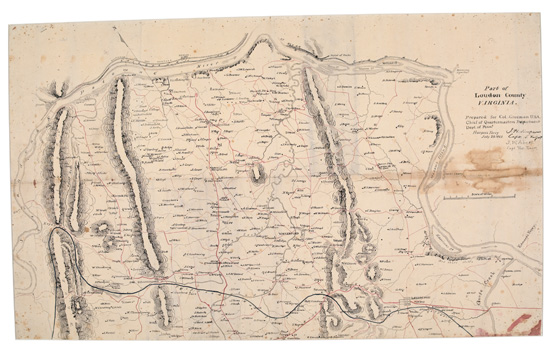
(CIVIL WAR.) Simpson, James H.; and James W. Abert. Part of Loudon County, Virginia. Manuscript map, pen, ink and wash on silk, 18 x 30 inches to sight, signed by the mapmakers; minor foxing, later inscription removed with some staining in blank area, early folds, laid down on archival board in 22 x 34-inch mat. Harpers Ferry, VA, 29 July 1861

Additional Details

Simpson and Abert prepared this handsome detailed map as captains and topographical engineers in the United States Army, at the request of Col. George H. Crosman of the Quartermasters Department of the Department of Pennsylvania. Both Abert and Simpson were already well known for their published reports of frontier exploration in the Southwest.
This map depicts the northern part of Loudoun County (the proper spelling), located in a curve of the Potomac on the Maryland border, northwest of Washington. As a border county, it was divided territory. Two of the towns had voted strongly against joining the Confederacy, but not enough to sway the county as a whole. The area is now a rapidly growing suburb of Washington, DC.
The map shows creeks, ridges, a proposed railroad, roads (drawn in red), the towns of Lovettsville, Hillsborough, Waterford, and Leesburg, and the names of hundreds of property owners. Harpers Ferry is shown on the far side of the river, just outside the northwestern county line. This area proved to be strategic for both sides during the war. Within three months, the county would be the site of a major battle, the Battle of Ball's Bluff. The bluff is shown on the map just north of Leesburg.