Nov 18, 2008 - Sale 2163

Sale 2163 - Lot 83

Price Realized: $ 2,400
?Final Price Realized includes Buyer’s Premium added to Hammer Price
Estimate: $ 4,000 - $ 6,000
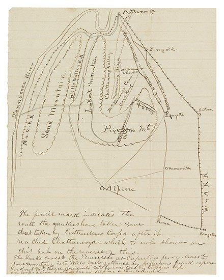
(CIVIL WAR--CONFEDERATE.) Manuscript maps of the Chickamauga Campaign. 2 manuscript maps on one 10 x 8-inch sheet (recto and verso); minor browning and very slight separations at intersection of folds. Np, [September 1863]

Additional Details

These maps were evidently drawn up by one of Polk's staff members in preparation for official reports. On the recto is a manuscript map of the terrain south of Chattanooga, extending on the west as far as the Tennessee River in Alabama, and as far as Kingston, GA, 50 miles to the south. Roads, railroads, mountains, and valleys are drawn in, and lines are superimposed in pencil. The caption reads "The pencil mark indicates the route the Yankees have taken save that taken by Crittenden's Corps after it reached Chattanooga, which is not shown on this but on the reverse of this." This route was taken by the Union troops under command of General Rosecrans from August 29 to mid-September 1863, in the weeks leading up to the Battle of Chickamauga.
On the verso is a more detailed map of the forces which converged at Rock Spring Church, GA on 13 September 1863: 3 divisions of Crittenden's Union Corps along the roads leading southward toward the church, and three Confederate brigades under Leonidas Polk just north of the church. Polk had been ordered to make an assault, but the Union forces retreated before he swung into action. Hence the caption of this map: "Location of the troops at what would have been the Battle of Rock Spring Church but for the enemy travelling."
with--a letter of authenticity from Polk's great-great-great-grandson testifying to its provenance.