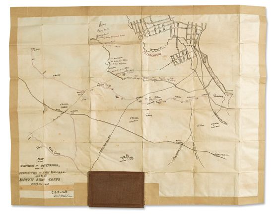
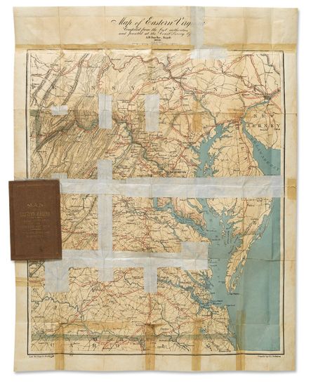
(CIVIL WAR--MAPS.) Map of the Environs of Petersburg, from the Appomattox to Fort Howard,Held by the Ninth Army Corps During the Siege. Manuscript map in red and black ink, 26 x 20 inches, drawn on the verso of W.L. Nicholson's printed "Map of Eastern Virginia," lithographed by Charles G. Krebs and published by the Coast Survey Office under A.D. Bache, 1862, mounted into original 12mo publisher's cloth binding; closed separations at folds, with three generations of tape repairs on the printed side and the edges of the manuscript side. Petersburg, VA, circa early 1865
A manuscript map showing the opposing trench lines at the Siege of Petersburg as they stood for several months in late 1864 and early 1865. The various units and forts along both lines are shown, sometimes in great detail. For example, the Confederate Battery 33 has four 3-inch rifles, while nearby Battery 31 has four Napoleons. The mine exploded in the Battle of the Crater is noted toward the right of the Confederate line. The map is signed "R.B. Ricketts," and inscribed below in a different hand "Major & Inspector of Artillery, 9th Army Corps." Robert Bruce Ricketts (1839-1918) was an artillery officer who had led a battery of the First Pennsylvania Light Artillery in a heroic defense of Cemetery Hill at Gettysburg. He was a major from 1 December 1864 until his promotion to colonel on 15 March 1865.