Jun 03, 2014 - Sale 2352

Sale 2352 - Lot 76

Price Realized: $ 25,000
?Final Price Realized includes Buyer’s Premium added to Hammer Price
Estimate: $ 20,000 - $ 30,000
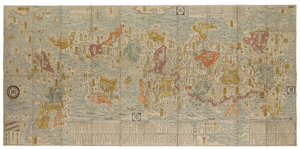
A LANDMARK MAP OF JAPAN (JAPAN.) Ishikawa Ryusen; Sagamiya Tahei, editor. Map of Japan. (Nihon kaisan chorikuzu zu.) Multi-sheet woodblock folding map of Japan. 830x1700 mm; old hand-color; slight separations at several intersecting folds, scattered wormholes, backed with archival paper obscuring faults, presents very well; modern Japanese-style cloth case. second edition, second issue. Kyoto, 1697

Additional Details

Ryusen's map contains a host of geographical information that far exceeds that of any other previously published maps of Japan. For example, the 53 stations of the Tokaido (Eastern Sea Route) are shown with great precision. This, along with the illustrations and the beautiful colors adopted by the ukiyo-e artist, was one reasons why Ryusen's maps were widely accepted among Japanese society.

"Ryusen is said to have been a pupil of the famous Moronobu. There is nothing fortuitous in the fact, therefore, that his maps strike the observer as little works of art notwithstanding their having naturally been intended for practical use in travel." -- M. Ramming, The Evolution of Cartography in Japan, Imago Mundi, 1937.

The map's legends show that by using one large square, one small square, and one circle, Ryusen made a distinction between large castles, small castles, and so-called "yashiki" castles, which were small and built in the style of a mansion. The map also tells us the names of the feudal lords of each castle and the incomes in rice of each fief. The large squares depicting large castles even include drawings of buildings and natural features within the castle compounds.

Ryusen's map also contains detailed information related to transportation. Shipping routes are drawn on the sea linking one port with another, with distances also included. Geographical information is not confined to Japan; a table at the top left of the map lists the names of the various cities and regions between China and Southeast Asia. It also lists distances in nautical miles from Nagasaki to as far afield as Holland.

Korea is drawn at the top left of the map and there is also the name of the Sea of Busan. The Ryukyu Islands are also pictured at the bottom left of the map and distances to both places are also given. The maps depicts a Chinese ship with a banner inscribed with the Chinese characters "Daimin".

The map also served as the basis for numerous European maps of the following century.

Yonemoto Marcia, Mapping Early Modern Japan; Berry, Japan in Print, pages 98-100; Walter, Japan, pages 64-67 and 195-196; cf. UC Berkeley, Japanese Historical Maps, Ca7.