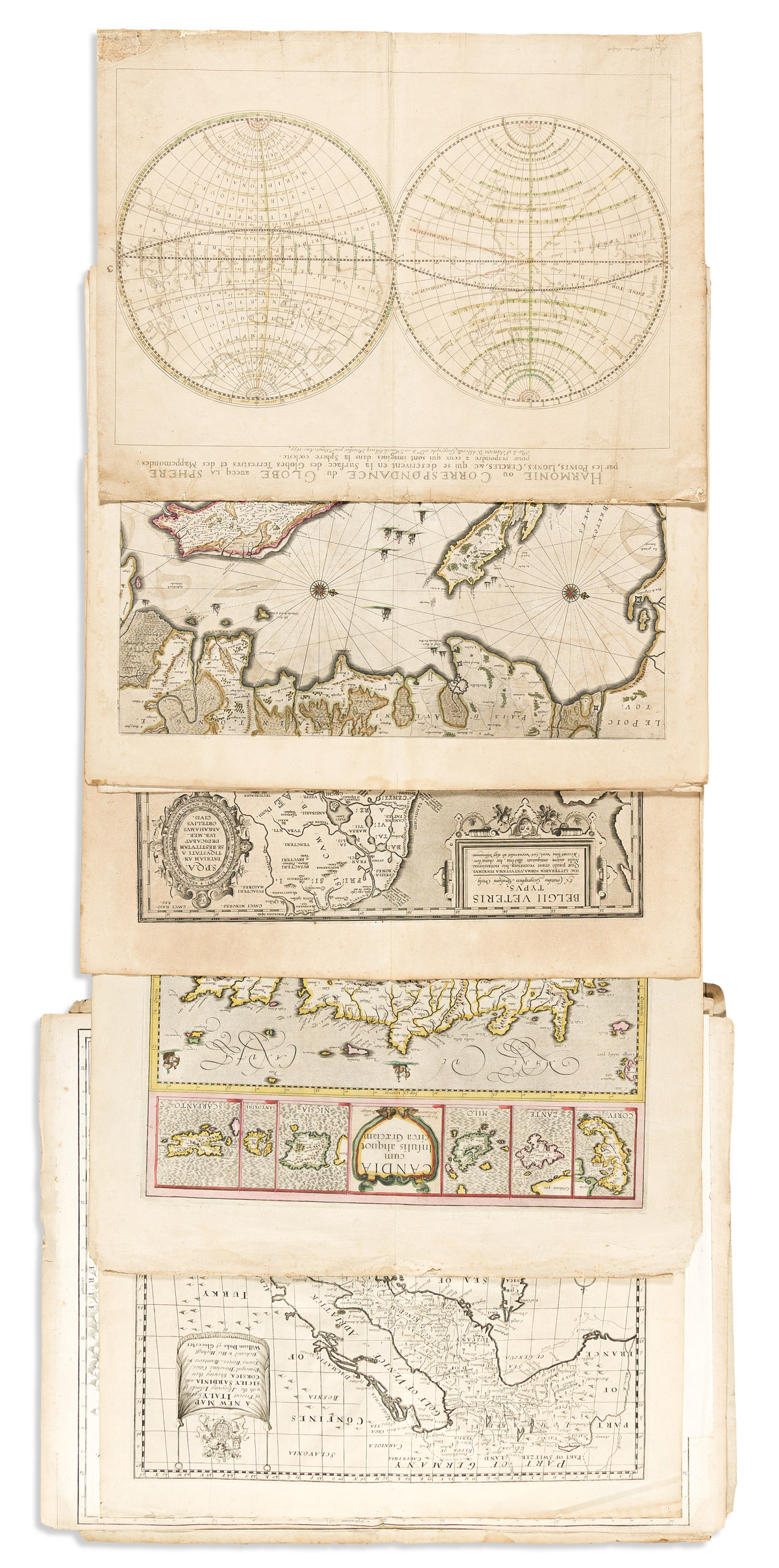
- Mercator/Hondius. Candia cum Insulis Aliquot circa Graeciam. (Crete and other Greek islands). 19 1/2x23 inches sheet size, wide margins, Latin text on verso; original hand-color in outline; edge wear, map fine. Amsterdam, circa 1630.
- Abraham Ortelius. Belgii Veteris Typus. (Low Countries in antiquity). 19 1/2x3 inches sheet size, wide margins, Latin text on verso; minor toning but nice. Van den Broecke 1603Lxiiij. Antwerp, 1603.
- Johannes Janssonius. Erpach Comitatus. (Erbach, Odenwald region, Germany). 19 1/4x23 1/4 inches sheet size, wide margins, Latin text on verso; original hand-color; offset of verdigris oxidation. Amsterdam, circa 1640.
- Johannes Janssonius. Palatinatus Bavariae. (Bavaria, Germany, north of the Danube River). 19 1/2x23 1/4 inches sheet size, wide margins, Latin text on verso; original hand-color; oxidation offset. Amsterdam, circa 1640.
- Johannes Janssonius. Insulae Divi Martini et Vliarus Vulgo l'Isle de Re et Oleron. (Île de Ré, Île d'Oléron, western French coast). 19 1/2x23 1/4 inches sheet size, wide margins, Latin text on verso; original hand-color; age toned, small tears. Amsterdam, circa 1640.
- Nicolas Sanson. Harmonie ou Correspondance du Globe avecq la Sphere par les Points, Lignes, Cercles &c. qui se Descrivent en la Surface des Globes Terrestres et des Mappemondes pour Respondre a Ceux qui sont Imagines dans la Sphere Coeleste. (Double hemispheric juxtaposition of terrestrial cartography against celestial diagramming). 17 1/2x22 1/2 inches sheet size, wide margins; original hand-color in outline; backed on a heavier sheet of early paper, several repairs. Paris, 1659.
- Jan Barend Elwe. Partie de la Nouvelle Grande Carte des Indes Orientales, Contenant les Terres du Mogol, Surate, Malabar, Coromandel... (India, Southeast Asia). 20 1/2x25 inches sheet size, lower margin trimmed to the neatline; original hand-color; stains, edge wear. Amsterdam, 1792.
- Justus Danckerts. Novissima et Accuratissima Helvetiae, Rhaetiae, Valesiae et Partis Sabaudiae Tabula. (Switzerland). 19 3/4x3 1/4 inches sheet size, narrow margins; original hand-color; stains, edge worn. Amsterdam, circa 1690.
- Johann Baptist Homann. Regiae Celsitudinis Sabaudicae Status in quo Ducatus Sabaudiae Principatus Pedemontium et Ducatus Montisferrati. (Liguria and Piedmont regions, Italy). 20 3/4x24 inches sheet size, ample margins; original hand-color; minor edge toning else nice. Nuremberg, circa 1730.
- Gilles Robert de Vaugondy. La Judee ou Terre Sainte Divisee en ses Douze Tribus. (Holy Land). 19 1/2x26 inches sheet size, upper margin shaved close; original hand-color in outline; edge toning but map nice. Paris, 1750.
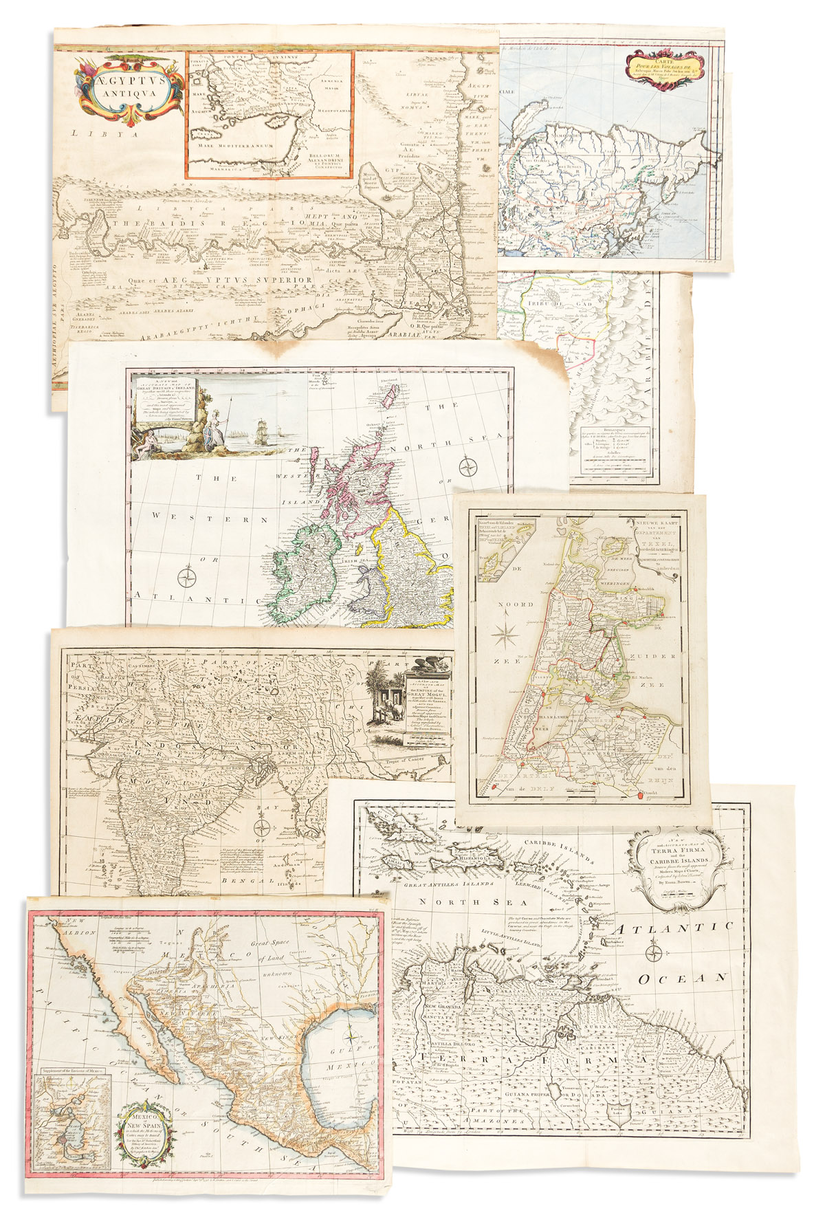
- [Pierre Du Val]. Aegyptus Antiqua. (Libya, Egypt). 16 1/4x19 inches sheet size, left and right margins shaved within image; hand-colored; light stains. Paris, circa 1690.
- Jacques Nicolas Bellin. Carte Pour les Voyages de Rubruquis, Marco Polo, Jen-kin-son, &c. (Europe, Asia). 10 1/4x16 inches sheet size, ample margins; hand-colored; original folds and binding tab. Paris, circa 1750.
- Emanuel Bowen. A New and Accurate Map of Terra Firma and the Caribbe Islands. (Caribbean, upper part of South America). 16x20 inches sheet size, wide margins; original folds, stain and small paper loss at lower left corner. London, 1747.
- Emanuel Bowen. A New and Accurate Map of Great Britain & Ireland. (British Isles). 16x21 1/4 inches sheet size, wide margins; original folds, stains and small paper loss at upper right corner. London, 1747.
- Emanuel Bowen. A New and Accurate Map of the Empire of the Great Mogul. (India, Southeast Asia). 16x17 1/2 inches sheet size, ample margins; generally good. London, 1747.
- Edward Wells. A New Map of Present Italy, Together with the Adjoyning Islands of Sicily, Sardinia, and Corsica. (Italy). 18 1/2x22 1/4 inches sheet size, wide margins; generally good. Oxford, 1700.
- Mortier, Covens & Zoon. Nieuwe Kaart van het Departement van Texel, Verdeeld in VII Ringen. (North Holland). 14x10 1/2 inches sheet size, wide margins; original hand-color; generally good. Amsterdam, circa 1790s.
- Thomas Kitchin. Mexico or New Spain; in Which the Motions of Cortes May be Traced. (Mexico). 12 1/2x15 1/2 inches sheet size, narrow margins; hand-colored; original folds, small stains. London, 1795.
- Thomas Jefferys. [Map of South America] (upper section only). Two sheets joined, 21 1/4x47 1/2 inches overall, ample margins; original hand-color in outline; generally good. London, 1770s.