Jun 11, 2009 - Sale 2183

Sale 2183 - Lot 29

Price Realized: $ 6,240
?Final Price Realized includes Buyer’s Premium added to Hammer Price
Estimate: $ 5,000 - $ 7,500
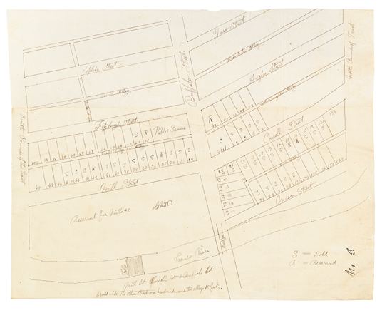
(NEW YORK--ROCHESTER.) Early manuscript atlas providing a detailed look at the early development of Rochester, including numerous manuscript copies of indenture/deeds for local tracts of land, 29 contemporary manuscript maps or plats, and 4 early printed maps of the area. Folio, original vellum, worn; internally clean. Rochester, 1820s-30s

Additional Details

Important early artifact detailing the growth of Rochester.
Nathaniel Rochester was born in Virginia. His family moved to North Carolina where he grew up and became involved in local politics and commerce. He became a member of the North Carolina General Assembly in 1777. He moved northward to Maryland and once again involved himself in local politics and commerce. He became involved with commerical traffic to upstate New York and in this capacity he made the acquaintance of Charles Carroll and William Fitzhugh, both directors of the Hagerstown Bank. Together they formed a partnership to begin acquiring lands in the area around what is now Rochester. In 1810 Rochester moved his family to Dansville, New York, and he became a political and commercial figure in the town. He soon began divesting himself of his properties in Dansville and turned his efforts to the area which would become Rochesterville. Rochester's location became important during the War of 1812 when dwellers from the shores of Lake Ontario moved inland to avoid the conflict. The town also became a center for the movement of military supplies and troops. When the idea of the Erie Canal was floated, Rochester was instrumental in securing a northern route for the canal, which would cross the Genesee River at Rochester. In 1821 he became instrumental in the creation of Monroe County, with Rochester as the county seat.
This important atlas contains a profusion of maps and plats from the time of the creation of Rochester. Detailed are the laying out of tracts of land, streets, a bridge over the Genesee River, etc. The maps were created by various hands and are contemporary copies of those filed for legal purposes.
The contemporary copies of the indentures also found in the atlas provide a history of the acquistion of land in the area by Rochester, Carroll, and Fitzhugh. Together, the maps and early legal documents illuminate the early history of a small town which would eventually become one of the great commercial centers of upstate New York.