- G.W. & C.B. Colton. Colton's Connecticut with Portions of New York & Rhode Island. Hand-colored engraved pocket map. 14x16 inches sheet size, folding into publisher's gilt cloth covers; minor wear and light foxing. New York, 1873.
- G.W. & C.B. Colton. Colton's Township Road Map of Western Connecticut Including Litchfield & Fairfield Counties and the Adjoining Country. Lithographed pocket map with partial outline hand-coloring. 31½x20½ inches sheet size, folding into publisher's gilt cloth covers; occasional separations at fold intersections. New York, 1886.
- George F. Cram. Cram's Railroad & Township Map of Illinois. Hand-colored lithographed pocket map. 22x16½ inches sheet size, folding into publisher's pictorial printed card wrappers; minor signs of age. Chicago, 1876.
- Rand, McNally, & Co.; and James Wyld. Colton's New Official Railroad Map of the United States, Canada and Mexico. Large wax engraved map with printed colors. 32x44½ inches overall, segmented, mounted on original linen backing and folding into publisher's cloth case; light wear. [Chicago] but London, 1885.
- G.W. & C.B. Colton. Colton's Sectional Map of the State of Iowa. Large hand-colored lithographed pocket map. 28x39 inches sheet size, folding into publisher's gilt cloth case; front cover detached, separations and splits at fold intersections. New York, 1874.
- G.W. & C.B. Colton. Colton's New Township Map of the State of Connecticut. Hand-colored lithographed pocket map. 18½x25 inches sheet size, folding into publisher's gilt cloth case; minor wear. New York, 1879.
- George F. Cram. Cram's Railroad and Township Map of Michigan. Hand-colored lithographed pocket map. 21½x17½ inches sheet size, folding into publisher's gilt cloth case; minor wear. Chicago, 1880.
- G.W. & C.B. Colton. Colton's Driving and Wheeling Map of the Country Twenty Five Miles North of the City of New York. Lithographed map overprinted in red. 28x24½ inches sheet size, folding into publisher's black-lettered cloth case with 3-page ad tipped in; lower section of map (including covers) torn and detached but repairable. New York, 1892.
- J.H. Colton. Colton's Railroad & Township Map of the State of New York with Parts of the Adjoining States & Canada. Hand-colored lithographed pocket map. 25x29½ inches sheet size, folding into publisher's gilt cloth case; large tears with old desiccated tape staining. New York, 1859.
- Hyde & Company. Driving Road Chart of the Country Surrounding New York City, Library and Carriage Form. Hand-colored lithographed map in 2 sections (of 4). 34x26½ inches each, mounted on original linen and folding into publisher's gilt cloth case; light wear only. New York, 1887.
- Chain & Hardy. Denver Illustrated. Leporello of tinted lithographed architectural and panoramic views. 3x82 inches overall, folding into publisher's gilt cloth case; very nice. Denver, 1881.
- Philip Fry & Co., and Janentzky & Co. Souvenirs of San Francisco. Leporello of glazed tinted lithographed architectural and panoramic views with a lithographed map tipped in at verso. 3x65 inches overall; map with adhesive stain and large split along fold line otherwise fine. Philadelphia, circa 1880.
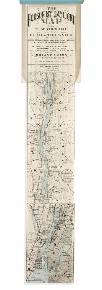
- Wallace Bruce. Panorama of the Hudson River Showing Both Sides of the River From New York to Albany. Large folding map of the Hudson River, 97 pages of photographic views. Publisher's cloth-backed embossed wrappers, lightly worn; map fine. New York, 1910.