Dec 08, 2005 - Sale 2060

Sale 2060 - Lot 10

Price Realized: $ 3,220
?Final Price Realized includes Buyer’s Premium added to Hammer Price
Estimate: $ 3,000 - $ 4,000
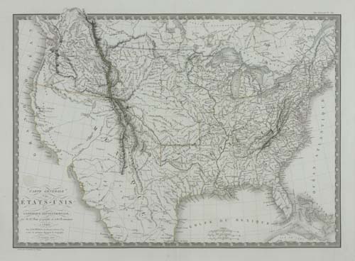
BRUE, ADRIEN HUBERT. Atlas Universel de Geographie Physique, Politique et Historique, Ancienne et Moderne. 35 double-page engraved maps, each hand-colored in outline (except map of France which is entirely colored), each with vellum finger-tab attached; plus 4 additional double-page maps inserted at a later date. Folio, 535x355 mm, original green roan, rebacked and retipped with similar color morocco; small expert repair to the map of the United States. Paris, 1822

Additional Details


The list of maps calls for 36 maps including two French maps, west (No. 18) and east (No. 19), but a larger double-page and in part folding map of all of France has been substituted for them by the publisher. The atlas was issued with two significant maps of North America, with the cartographic influences of Lewis and Clark clearly evident - "Carte de l'Amerique Septentrionale" dated Janvier 1820 and "Carte Generale des Etats-Unis de l'Amerique Septentrionale" dated December 1820 (Wheat 336), both showing Ft. Clatsop and Ft. Astoria at the mouth of the Columbia, with what was to be Oregon named "Colombia". In Mexico both maps show the province of San Luis Potosi with no mention of Texas. However, in this unusual copy there are two additional maps by Brue, on same size paper as the original maps, apparently inserted later without vellum tabs - "Carte Generale des Etats-Unis, du Canada et d'une Partie des Pays Adjacent" dated Paris 1825, and "Carte Generale des Etats-Unis Mexicains et des Provinces-Unies de l'Amerique Centrale" also dated Paris 1825 (Wheat 361), both showing Oregon and Texas and with much more detail in the California-Utah region than the original 1820 maps. In addition, at the end of the atlas, inserted later and on slightly smaller trimmed paper without vellum tabs, is the title page from Pierre Lapie's Atlas Universel de Geographie Ancienne et Moderne followed by two of Lapie's double page maps - "Carte de l'Amerique Septentrionale" dated Paris 1830 and "Carte des Etats-Unis d'Amerique" dated Paris 1832 (Wheat apparently unaware of this 1832 edition, describes the later 1837 edition in Wheat 428), both showing the District of Columbia and Texas and with no mention of Oregon or San Luis Potosi. All maps with a small Brue or Lapie blindstamp. Phillips Atlases 758 (later 1834 edition). Not in Rumsey.