Dec 08, 2005 - Sale 2060

Sale 2060 - Lot 60

Price Realized: $ 6,440
?Final Price Realized includes Buyer’s Premium added to Hammer Price
Estimate: $ 2,000 - $ 3,000
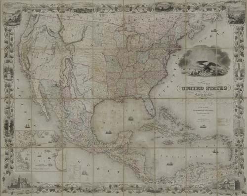
COLTON, J. H. and G. W. Map of the United States of America, the British Provinces, Mexico, the West Indies and Central America with part of New Granada and Venezuela. Hand-colored engraved case map in 32 sections, 860x1075 mm overall; moderately toned and foxed; linen-backed, some separation of linen at scattered intersecting folds; housed in a modern cloth folding box. New York, 1849

Additional Details


"Although copyrighted in 1848, no copy of this map has been located which bears that date in the title"--Wheat, Maps of the California Gold Region 74. According to Rumsey this is the second 1849 edition, differing from the first by the addition of the "El Dorado Gold Region" north of the Feather River in what is now California and Fremont's route shown along the Humboldt River in present day Nevada. All these additional features are present here. However, the copy here may be an unrecorded third 1849 edition because it differs in the spelling of the word "capitol" under the large corner vignette. Apparently on the copies cited by Wheat and Rumsey the word is incorrectly spelled as "capital."
This is an important map showing the west of the United States just after the completion of the war with Mexico. It shows a large "Upper or New California", Nebraska and Oregon Territories, and hints of a future New Mexico Territory with a label so named on the west side of Santa Fe. However, Texas is oddly shaped, extending on the west as far as Santa Fe and Albuquerque. On the north Texas terminates in the vicinity of Pike's Peak. The gold regions in California are not only clearly shown but also colored in yellow. An engraved annotation at the edge of Salt Lake declares this region to be a "Mormon Sett." and a "Mormon Fort" is shown in the vicinity. Rumsey 4312.