Dec 08, 2005 - Sale 2060

Sale 2060 - Lot 26

Price Realized: $ 3,450
?Final Price Realized includes Buyer’s Premium added to Hammer Price
Estimate: $ 4,000 - $ 6,000
DeSILVER, CHARLES. A New Universal Atlas. Color lithographed title, 72 hand-colored engraved mapsheets, lithographed double-page map, hand-colored chart of rivers and mountains [complete]. Folio, 430x360 mm, publisher's custom 1/2 calf over cloth covers (rather than marbled boards), extremities worn, spine ends frayed, with the original leather cover label; internally very bright and clean; bookplate. Philadelphia, 1856

Additional Details


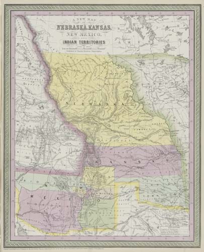
This is an unrecorded mid-1856 issue of the rare DeSilver editions of Mitchell's New Universal Atlas. All maps, plans and charts, except the chart of the Baltic, have the pink/green "Mitchell" double-borders rather than the later vine-type "Colton" borders adopted by DeSilver. The competition with Mitchell's New Universal Atlas heated up with the publication of Colton's large-format Atlas of the World - with its first volume of American maps published in 1855. When DeSilver took over the publication of Mitchell's New Universal Atlas in late 1855 (Rumsey 3008) from Cowperthwait, DeSilver & Butler, who published the early 1855 edition (Rumsey 4328), he realized that his atlas was missing a mid-continent map showing the new Territories of Kansas and Nebraska created by the Kansas-Nebraska Congressional Act of 30 May 1854. There was great public interest in maps of those two new Territories because of the politics involved. The single map of California, Oregon, Washington, Utah & New Mexico in DeSilver's atlas - which shows on its eastern end parts of Kansas and Nebraska - was not enough. It could not compete with Colton's new separate map of Nebraska and Kanzas [sic] included in the Atlas of the World. Therefore, in 1856 DeSilver added a new map to the New Universal Atlas titled A New Map of Nebraska, Kansas, New Mexico, and Indian Territories. This new map is the most important map and the centerpiece of DeSilver's editions of the New Universal Atlas published between 1856 and 1858 (last known DeSilver edition). This map is rare because it appeared only for about a year in the atlas. Sometime in 1857 it was replaced by a revised edition. The copy of the map here is colored very brightly, un-numbered, not listed in Table of Contents, and placed between the maps of California and Mexico. Rumsey lists an "early 1856" edition (Rumsey 2838) and a "late 1856" edition (Rumsey 3268) of DeSilver's atlas. The copy here falls in-between and can be named the "mid 1856" edition. It has some features of both the "early" and "late" 1856 editions. This copy also has a custom publisher's binding which differs from the more common trade copies. It has the purchaser's name gilt-lettered on the front cover, "F. A. Drexel."