Apr 12, 2003 - Sale 1967

Sale 1967 - Lot 214

Unsold
Estimate: $ 80,000 - $ 120,000
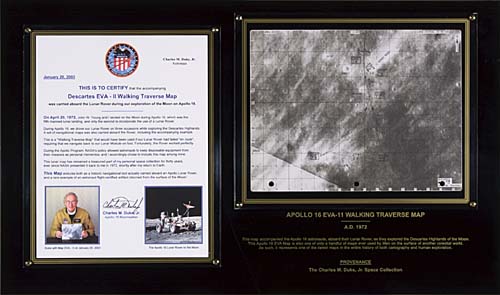
A GREAT CARTOGRAPHIC RARITY -- FOR EXPLORING THE MOON'S SURFACE FLOWN Apollo XVI Lunar Navigational Map. Approximately 7.5x10.5 inches lunar surface navigational map mounted on a 15x25 inch black plexiglas frame with gold color trim and lettering which reads in part, "This map accompanied the Apollo 16 astronauts, aboard their lunar rover, as they explored the Descartes Highlands of the Moon. This Apollo EVA Map is also one of only a handful of maps ever used by Man on the surface of another celestial world. As such, it represents one of the rarest maps in the history of both cartography and human exploration." Map removable to view verso of map. Np: 1972

Additional Details


All surface maps were carried out to the lunar surface during the first EVA and placed in a storage area beneath the Lunar Roving Vehicle (LRV, "Rover") seats or in a spot next to the 16mm film camera if they were used during traverses. This map shows the southern most points of the contingency EVA II walking path to be used in case of failure of the Rover. It almost became a critical item to use to complete EVA II and return to the LM when at the Station 8 area the Rover appeared to have lost rear steering and rear drive capability. The Rover still had front wheel drive and steering, but if that was lost too, Young and Duke would have to abandon the Rover and been forced to use this contingency EVA II chart to finish the EVA.
Inscribed and signed by Duke on the reverse side of the map,