Apr 12, 2003 - Sale 1967

Sale 1967 - Lot 215

Price Realized: $ 11,500
?Final Price Realized includes Buyer’s Premium added to Hammer Price
Estimate: $ 12,000 - $ 18,000
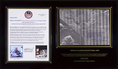
THE TRAJECTORY BEFORE LANDING FLOWN Apollo XVI Lunar Orbit Map. Approximately 7.5x10.5 inch lunar orbit navigational map, number 15 of 24 plates comprising the Lunar Orbit Monitor Chart carried aboard LM 'Orion'. The present map illustrates some 500 square miles of the Gutenberg crater area at approximately 41 to 44 degrees East longitude and 6 to 10 degrees South latitude. 'Orion' flew over this area approximately 8 minutes before the Powered Descent Initiation (PDI) engine burn that would lower the LM to the surface. Np: 1972

Additional Details


The map is mounted on a 15x25 inch black plexiglas frame with gold color trim and lettering which reads in part: "This map was a navigational aid which helped guide some of the first humans to landfall on another celestial world. As such, it represents one of the rarest maps in the entire history of both cartography and human exploration."
With a certificate by Duke describing additional flight details which shows a January 2003 image of Duke holding this exact map and an image of Duke on the Moon saluting the U.S. flag. The map itself is inscribed and signed by Duke with: "This map was used aboard the lunar module 'Orion' during our landing on the Moon. It then remained in the 'Orion' on the Moon for nearly 72 hours. Charles M. Duke, Jr., Apollo 16 Moonwalker".
Duke has written "Flight Trajectory" with an arrow to show the LM orbital trajectory path that is plotted with a white line.