Mar 18, 2006 - Sale 2073

Sale 2073 - Lot 254

Price Realized: $ 1,380
?Final Price Realized includes Buyer’s Premium added to Hammer Price
Estimate: $ 1,500 - $ 1,800
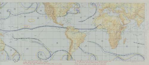
FLOWN World Weather Chart. An approximately 39x14 inch, folded, multi-colored world map titled "Skylab Weather Briefing Chart (NWB), Edition 1, July 1972." All major weather fronts, High and Low pressure regions, and rain shower areas have been hand drawn on the chart. Additional manuscript notes read: "Forecast Map for 1300 GMT, 5/25/73," shows the predicted launch and orbital path for SL-2, observed weather for several areas, and define symbols written on the chart. Defense Mapping for NASA, July 1972

Additional Details


A standard activity prior to any U.S. manned launch is to provide the flight crew with a world weather briefing. A launch abort, off-course flight path, or early re-entry could place the crew almost anywhere on the planet. Astronauts Conrad, Kerwin, and Weitz were given their briefing from this chart and carried it with them in case any flight mishap required its use. Inscribed and signed along the right border with: "Used at our pre-launch weather briefing and carried in the SL-2 CM during the Skylab I mission, Paul Weitz, PLT."