?Final Price Realized includes Buyer’s Premium added to Hammer Price
Estimate: $ 25,000 - $ 35,000
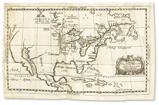
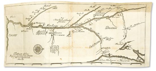
HENNEPIN, LOUIS. Beschreibung der Landschafft Louisiana. 2 folding maps. 425 pages plus 3 final blanks. 24mo, contemporary vellum, minor wear, rear joint repaired, original clasps intact, early stamp reading "IKPAR 1689" on front cover; faint dampstaining and a short closed separation on first map, second map laid down skillfully on paper and reinserted, catalogue description pasted to rear pastedown; early inscription on title page, bookplate of Niagara Falls scholar Peter A. Porter on front pastedown, later bookplate on front free endpaper. Nuremberg: Andres Otto, 1689
first german edition of Hennepin's 1683 Description de la Louisiane. Also includes a German translation of Marquette's 1673 account of the northern Mississippi. This edition is most notable for its two important maps. The first, "Tabula Exhibens Novam Franciam et Louisianam," is adapted from the map in Hennepin's 1683 first edition, the first to accurately hypothesize the route of the Mississippi River. Here the Mississippi is depicted as "Fl Colbert," with the southern portion below Hennepin's exploration marked with a dotted line. The present map is the first to use the name "Louisiana"; the 1683 map had called it La Louisiane. Also, this version depicts North America exclusively, while the original 1683 map included portions of the European and South American coasts. The second map, "Tabula Exhibens Regiones Quasdam Recens Detectas in America Septentrionali, anno 1673," is a second edition of the map by Joliet published in Thévenot's 1681 travels, the first map to name Lake Michigan (here Lacus Mitchigami). European Americana 689/94; JCB page 207; Schwartz & Ehrenberg, pages 128-130 (map sources); Streit 2742. One copy known at auction since 1950.