Jun 05, 2008 - Sale 2148

Sale 2148 - Lot 214

Price Realized: $ 28,800
?Final Price Realized includes Buyer’s Premium added to Hammer Price
Estimate: $ 25,000 - $ 35,000
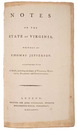
FIRST PUBLISHED ENGLISH EDITION,COMPLETE WITH MAP JEFFERSON, THOMAS. Notes on the State of Virginia. Folding map hand-colored in outline (minor separations at center folds, light offsetting, slightly unevenly trimmed), folding table of Indian tribes (near flawless), other illustrations. [4], 382 pages. 8vo, contemporary calf, tastefully rebacked with original gilt-lettered spine label laid on and gilt raised bands, corners worn but stable; original endpapers and integral blank, light marginal staining on endpapers and title, early unobtrusive marginalia on pages 64-229, marginal hole on H2, tear with slight loss on T4; early 20th-century armorial bookplate of John Wm. Roy Crawford on front pastedown, signature "F. Maseres, July 30, 1787" on front free endpaper. In an attractive modern slipcase with gilt-stamped morocco label and four-fold folder by the James Macdonald Company. London: John Stockdale, 1787

Additional Details

first edition published in english. This work had its origins in a questionnaire circulated to America's governors in 1781 by François Barbé-Marbois, a French diplomat stationed in Philadelphia. Jefferson, after completing his term as Virginia's governor, responded to these questions on 20 December 1781. Realizing that his efforts might interest a broader audience, he continued to expand his manuscript over the coming years. In 1785, he had a handful of copies printed for private distribution, which was followed by a French translation in 1786. The present edition, printed in 1787, is generally considered the first published edition in English. It was the first (and only) book-length work Jefferson ever published.

The published Notes remained framed in terms of Jefferson's responses to Barbé-Marbois's 23 questions. Jefferson went much further than the questions demanded, however. Asked "The number of its inhabitants?", Jefferson responded with a 10-page demographic analysis of Virginia. The work contains extended sections on Virginia's economy, slavery, Indians, constitution, and laws. It concludes with 3 appendices: a commentary on the text by Charles Thomson, secretary of the Continental Congress; the 1783 draft of Virginia's constitution; and the Virginia Assembly's 1786 act establishing religious freedom.

The map, titled "A Map of the Country between Albemarle Sound and Lake Erie" and found here in unusually strong condition, depicts the bulk of modern-day Delaware, Maryland, Pennsylvania, and West Virginia, as well as Virginia, carefully noting its sources in earlier maps, and indicating that "additions have been made, where they could be made on sure ground." These additions seem to have been Jefferson's own, making this "the only map attributed to Jefferson" (Schwartz & Ehrenberg, Mapping of America, 209), though it was almost entirely derived from other sources.

This copy was originally the property of English author Francis Maseres (1731-1824), a long-time baron of the exchequer, and judge in the London Sheriff's Court.
Howes J78, Phillips page 984 (map), Sabin 35896, Sellers 762 (map).
a fresh attractive copy of jefferson's first full-length book.