Dec 08, 2005 - Sale 2060

Sale 2060 - Lot 125

Price Realized: $ 2,070
?Final Price Realized includes Buyer’s Premium added to Hammer Price
Estimate: $ 800 - $ 1,200
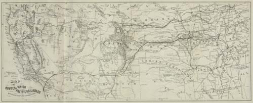
KANSAS PACIFIC RAILWAY. The Union Pacific Railway Eastern Division, or (Kansas Pacific Railway.) Importance of its Route to all Sections of the Country. Lithographed folding map. 50 pages. 8vo, modern wrappers. Washington: Joseph L. Pearson, 1868

Additional Details


Map shows the country from Indiana and Alabama on the east to the Pacific on the west. The map centers on the midsection of the west - with California, Nevada, Utah, Colorado, Nebraska, Kansas, Indian Territory, Missouri and Arkansas shown in full. Most of Arizona and New Mexico are also depicted but only the southern parts of Oregon, Idaho and Dacotah are shown. Present day Wyoming is not named and is still a part of Dacotah Territory which borders with Colorado. The proposed rail routes are fully shown as well. Wheat 1186 states that it is "much superior cartographically" to the maps in three separate pamphlets issued the same year by the competing Union Pacific Rail Road. Not in Ristow or Rumsey or Modelski. Wheat 1186.