Dec 08, 2005 - Sale 2060

Sale 2060 - Lot 69

Price Realized: $ 3,450
?Final Price Realized includes Buyer’s Premium added to Hammer Price
Estimate: $ 1,500 - $ 2,500
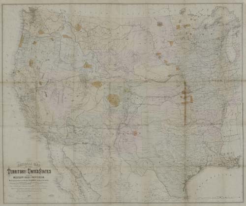
KEELER, WILLIAM J. National Map of the Territory of the United States from the Mississippi River to the Pacific Ocean. Hand-colored 4-sheet lithographed map joined, not dissected, but comprising the equivalent of 35 sections, 1505x1250 mm overall; some moderate foxing, minor separation at some of the intersecting folds; linen-backed; folds into the original gilt lettered 4to format cloth case, case a bit faded, front hinge weak; dedication inscription to H. Van Aerman of the House of Representatives from the Commissioner of Indian Affairs, N. G. Taylor. Washington, 1867

Additional Details


Indian Reservations are delineated, named and colored in brown. Shows forts, military posts and railroads - the latter in blue if completed and in red if still in progress. An Explanation (Legend) in the bottom-right of the map shows the coloring used to depict deposits of gold, silver, copper, coal and iron. A very unusual delineation of Dakota Territory is shown, encompassing the North and South Dakota of today and virtually all of today's Wyoming (created 1868). Large deposits of gold are shown in Colorado. Rumsey calls this copy the "second edition" to distinguish it from the "first" also dated 1867 but lacking the delineation and naming of the Indian Reservations and without Ft. D. A. Russell at Cheyenne. He farther states: "I cannot find any references to the existence of two editions of this map" and suggests that the map may have been issued in 1868. Wheat 1170 calls this map "an imposing production . . . Keeler's large and imposing map is of almost unmanageable size, but it offers something of interest in every part of the West and is worth wrestling with." Rumsey 4737. Wheat 1170.