?Final Price Realized includes Buyer’s Premium added to Hammer Price
Estimate: $ 15,000 - $ 25,000
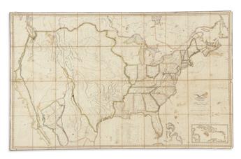
MELISH, JOHN. Map of the United States with the Contiguous British & Spanish Possessions. Engraved case map dissected in 40 sections mounted to original linen with silk edging, folding into marbled paper self-wrappers. 36x58 inches overall size; original outline hand-color; housed in original worn 8vo format morocco backed case with original ties; scattered staining, very minor chipping to fold intersections near title not affecting map. Philadelphia, 1816
A very important piece of American cartography, this map is the first representation of the continental United States to be shown as an integrated landmass from the Atlantic Ocean to the Pacific, systematically incorporating the explorations and mappings of Lewis and Clark, Zebulon Pike, Aaron Arrowsmith, Alexander von Humboldt and others.
Melish continually issued updated editions of his map, printing 23 altered states through 1823. This is Ristow's 7th state of the 1816 first edition with the designation "Mississippi Territory" changed, dividing the states and so naming them Mississippi and Alabama Territory. Ristow, A la Carte, page 173.