Dec 08, 2005 - Sale 2060

Sale 2060 - Lot 41

Price Realized: $ 34,500
?Final Price Realized includes Buyer’s Premium added to Hammer Price
Estimate: $ 40,000 - $ 50,000
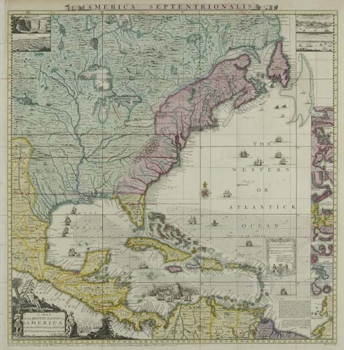
POPPLE, HENRY. A Map of the British Empire in America with the French and Spanish Settlements adjacent thereto. 20-sheet map in uncolored state, plus key map in full contemporary color. Key map measures 495x490 mm (20-sheet map if joined measuring 2400x2335 mm). Folio, calf gilt by Sangorski & Sutcliffe. 20-sheet map in state 7; key map in state 3; letterpress Table of Contents in state 1. London, 1733 [i.e. 1739/40]

Additional Details


The second most important map of Eastern North America and the West Indies, after John Mitchell's map of 1755. Applauded by George Washington, John Adams, Benjamin Franklin, and many others of the period. The map was used in attempts to resolve territorial conflict between the British and the French during the French & Indian War. It was used during the late 19th century dispute between Britain and Venezuela over British Guyana. A map that forms the basis of any serious American map collection.
State 7 of the 20-Sheet map was published by William Henry Toms and Samuel Harding in London from August 1739 through circa 1745. It was the first issue to be published by the engraver of the map W.H. Toms after he bought it jointly with his partner Samuel Harding from Henry Popple in August 1739 - at the beginning of the War of Jenkins' Ear in the West Indies. The map itself differs from the last state of this 20-sheet map published by Popple only in the imprint on sheet 17 - "Sold by S: Harding on the Pavement in St. Martins Lane, and by W. H. Toms Engraver in Union Court near Hatton Garden Holborn", followed by the pricing of the map in Sheets, bound and on "Rollers & Colour'd". However, the main difference between the copies of the map sold by Popple and those sold by Toms and Harding was the price. Popple sold the map at 4 Guineas (4 pounds, 4 shillings). The enterprising pair of Toms and Harding cut the price of the bound map by more than half to 1 pound, 16 shillings and 6 pennies. The precise August 1739 date of the publication of this State of the map was established by reviewing the August advertisements of Toms and Harding in the London papers - in "The General Evening Post" of August 9-11, 1739 and "The London Evening-Post" of August 16-18, 1739. Babinski, page 6., note 5.
State 3 of the Key map was published circa 1740 and probably was printed only for a few months before being replaced by State 4 (track of Spanish Galleons added). It is the rarest of the Popple Key maps with the exception of the ones published by Steel during the American Revolution (with the dedication changed from Queen to King). This State 3 Key map has an interesting history and was probably published as the result of and a response to sarcastic comments in London papers by George Foster, who published a competing "Seat of War in the West Indies" map in 1740. Foster compared his map with State 2 of what he called Popple's "Miniature Map" in an advertisement published in the February 22, 1740 issue of "The Daily Post" - disparaging the Key map for not showing "Cumana, the Caraccas, Coro, Rio de la Hecha, Sancta Martha, Cartago, the Logwood Creeks", etc which appeared on Foster's smaller map. As a result Toms added a number of new place-names on this State 3 Key map, compared to State 2 of the map published in 1739. Babinski, page 7, 18. The letterpress Table of Contents is in its first State, where the entry enumerated "XIII" is missing (corrected in State 2). Babinski, Popple, figure 19. Only about one out of 3 bound copies of the Popple map come with the Table of Contents leaf . Babinski, Popple, page 7.