Dec 08, 2005 - Sale 2060

Sale 2060 - Lot 98

Price Realized: $ 2,185
?Final Price Realized includes Buyer’s Premium added to Hammer Price
Estimate: $ 1,500 - $ 2,500
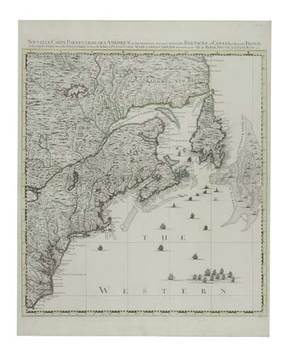
POPPLE, HENRY. Nouvelle Carte Particuliere de L'Amerique ou sont exactement marquees la Nouvelle Bretagne, le Canada ou Nouvelle France, la Nouvelle Ecosse, [etc.]. Double-page engraved map, 615x545 mm, margins trimmed to platemarks on sides (but ample), margins wide on top and bottom; hand-colored in outline. Amsterdam: Covens and Mortier, 1755

Additional Details


The North-East sheet, in state 3, of the 4-sheet Covens and Mortier copy of Popple's map. This finely engraved map shows Eastern Canada, New England, New York, New Jersey, Maryland large parts of Pennsylvania, Virginia and North Carolina. The Covens & Mortier 4-sheet copy of Popple's map is a reduction of the 20-sheet map, not an enlarged copy of the Key map. There were few changes between the first and second states, but this third state contains major geographical changes. Here, on the North-East sheet, compared with States 1 and 2, the modifications are primarily in the area of Lake Ontario - its east end changed in shape, moved south and extended farther to the east, Forts Oswego and Frontenac shown, the river system around the lake changed and a new annotation added - "Sources of the Ohio according to the Indians". Babinski, Popple, page 14 and figures 71 and 72.