Dec 04, 2008 - Sale 2165

Sale 2165 - Lot 83

Price Realized: $ 19,200
?Final Price Realized includes Buyer’s Premium added to Hammer Price
Estimate: $ 10,000 - $ 15,000
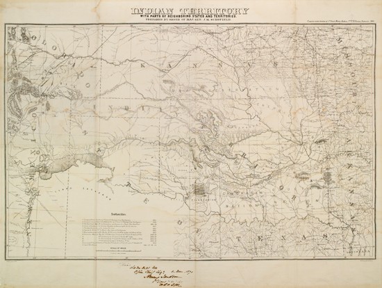
SCHOFIELD, J. M.; Major General. Indian Territory with Parts of Neighboring States and Territories. Compiled under the direction of 1st Lieut. Henry Jackson, 7th U.S. Cavalry. Large photo-lithographed folding map on cloth, 700x940 mm (27 3/4x36 3/4 inches); slight scattered dampstaining; Inscribed and Signed by 1st Lieutenant Jackson in the bottom margin; matted. Washington, circa September 1869

Additional Details

Important mapping that includes the area of the Battle of Little Big Horn, which took place in June 1876. The mapping was done under the direction of 1st Lieutenant Henry Jackson at the order of Maj. Gen. Schofield. A signed inscription in Jackson''s hand at the bottom of the map reads, "Official [?] Office Chief Eng: 8. Mar. 1870. Henry Jackson 1st Lieut. 7th U. S. Cav [?]." This inscription might suggest that the map was Jackson''s personal copy. The map is printed on cloth as it was intended for field use by the 7th United States Cavalry.
Jackson received his commission as 2nd Lieutenant, 7th Cavalry in July 1866. He was commissioned 1st Lieut. in July 1867. He was working in the office of the chief Signal Officer of the U. S. Army when he supervised the creation of this map. On 12 June 1876 he joined his regiment (Company C) in the field. On 25 June 1876 he was promoted to Captain (the same day as the Battle of Little Big Horn and immediately transferred to Company F to fill the vacancy left by the death of Tom Custer.
Maj. Gen. Schofield served with distinction during the Civil War and as Secretary of War during the final days of the Johnson administration. He commanded the Department of the Missouri from March 1869 until May 1870, and the map was made during this period. In 1888 he became the commanding general of the United States Army.