Oct 10, 2002 - Sale 1946

Sale 1946 - Lot 364

Price Realized: $ 16,100
?Final Price Realized includes Buyer’s Premium added to Hammer Price
Estimate: $ 5,000 - $ 7,500
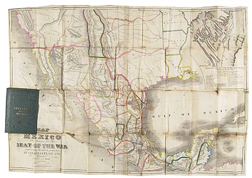
POCKET MAP SHOWING TEXAS IN 1847 STEALEY, GEORGE. Map of Mexico Showing the Seat of the War. Lithographed folding pocket map, 595x850 mm, hand-colored in outline; separations at intersections, minor browning along the folds, tear in Pacific Ocean, some linen tape on verso along several separations. bound with:<> Butler, W. H. G. Sketch of Mexico.<> 3-32 pages. 8vo; lacks the first leaf. Louisville, 1847

Additional Details


"George Stealey, a civil engineer, published in 1847 at Louisville, Kentucky, a large Map of Mexico . . . It displays Fremont's route up the 'Fertile Valley' now known as the San Joaquin, acoss Walker's Pass and thence by way of the 'Great Spanish Trail' which is prominently shown extending northeasterly from the 'City of Angels' . . . At Santa Fe, Fort Marcy now appears, and the locations of Mexican War battles are given, with a detailed insert Plan of the 'Battle of Buena Vista'"--Wheat, Mapping the Transmississippi West 553; Streeter Sale VI:3870. Neither American Book Prices Current nor the Antique Map Price Record show any copies coming to auction since the Streeter Sale. OCLC locates just two institutional holdings. <