?Final Price Realized includes Buyer’s Premium added to Hammer Price
Estimate: $ 1,200 - $ 1,800
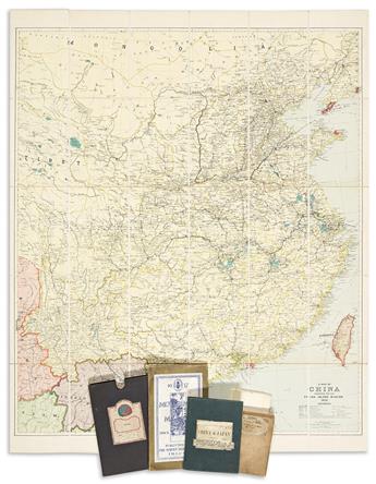
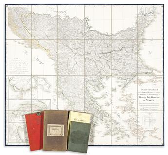
(CASE MAPS.) Group of 9 nineteenth-and-early-twentieth-century engraved or lithographed case maps of various locations. Individual photographs on request. Vp, vd
- Edward Stanford. A Map of China. 43 1/2x45 inches overall, segmented, mounted on original linen backing with yellow paper self-wrappers and folding into publisher's 8vo format cloth slipcase; minor wear. London: China Inland Mission, 1928.
- Edward Stanford. Stanford's Map of China and Japan with the Adjacent Parts of the Russian Empire, India, Burma &c. 26 1/2x40 1/2 inches overall, segmented, mounted on original linen backing with printed paper self-wrapper and folding into publisher's 8vo format cloth covers; minor wear, ink stamp at lower right. London, 1917.
- The American Express Co. Map of Peking. 31x21 1/2 inches sheet size; tears along fold lines. Np, circa 1930.
- Federated Malay States Survey Department. Motor Map of Malaya. 39x27 inches overall, mounted to original linen backing and folding into publisher's printed covers; minor wear. Kuala Lumpur, 1937.
- Pierre Tardieu. Theatre de la Guerre Carte de la Turquie d'Europe et d'Asie. 23 1/2x34 inches overall, segmented and mounted to original linen backing with printed Clerot shop label pasted to verso; general age toning. Paris, 1854.
- James Wyld. Map of the Ottoman Empire the Black Sea and the Frontiers of Russia and Persia. 17 1/2x25 inches overall, segmented, mounted to original linen backing and folding into publisher's 8vo format cloth case; minor wear. London, 1853.
- Heinrich Kiepert. General Karte des Osmanischen Reiches in Asien. 27 1/2x41 1/2 inches overall, segmented, mounted to original linen backing and folding into publisher's 8vo format cloth case with Edward Stanford label pasted on; staining. Berlin, 1869.
- Guillaume de Vaudoncourt. Carte Generale de la Turquie d'Europe a la Droite du Danube ou des Beglerbegliks de Roum Jli, Bosn et Moree. 34x38 inches overall, segmented, mounted on original linen backing and folding into original red paper slipcase; minor wear. [Munich], 1821.
- James Wyld. Wyld's Military Staff Map of Central Asia and Afghanistan. 35 1/2x50 inches overall, segmented, mounted on original linen backing with printed yellow paper self-wrappers; minor wear. London, circa 1880.